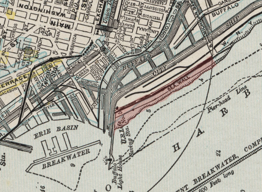
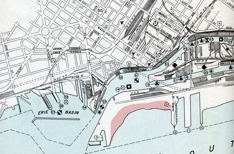
1900 map of the Buffalo harbor area. Highlighted in red is the "sea wall strip" of beach. Image source: private collection
The dream of a downtown public bathing beach may have begun in 1931, but there would be no beach if Buffalo's harbor development had not done its work first. The harbor built of timber by Samuel Wilkeson in the early 1820's did not bear up under Lake Erie storms. When the U.S. government agreed to improvements and the installation of a lighthouse, the south entrance to the harbor was extended by 1,790 feet beginning in 1826. This pier, created by cemented stone, is what we see today from the Hatch (north) side of the harbor entrance. The long extension, called the South Pier, prevented sand from being deposited in the harbor mouth. This sand instead accumulated along the shore of the small "low and sandy spit" of land between the Buffalo River and the lake.
Everyone in the city was aware of the storm surges that washed over that land, damaging ships at berth; the very construction of the South Pier allowed lake waves to accumulate behind it and push over the sliver of land and into the Buffalo River. In 1837, the city petitioned the U.S. government for a sea wall to be built on the slender spit of land. Beginning in 1838, an earthen sea wall was built with a masonry facing that, by 1840, was 3,770' long. This sufficed until the October, 1844 seiche destroyed the wall and engulfed the city. A new sea wall was not constructed until 1866, though construction of breakwaters at that time diminshed the need for it.
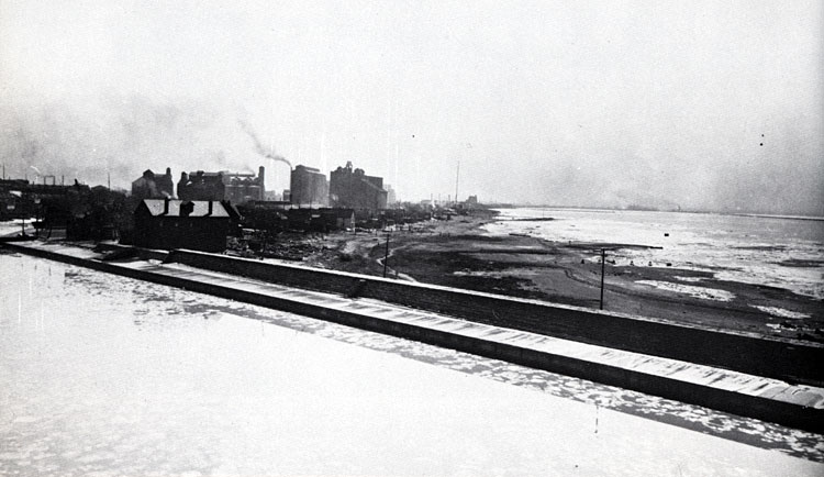
Looking from the South Pier harbor entrance toward the beach area, early 1900s. Image source: NARA
The construction of the sea wall brought squatters onto the land, Irish immigrants at one end and Portuguese at the other. They called their land "the beach," "Wall St," "the island," Buffalo's Bohemia," and "the sea wall strip." Behind the sea wall they constructed shacks and built a life in commercial fishing. Over several generations, these shanties were improved into houses. Rowing clubs also built their clubhouses; saloons served all. The squatters did not own the land, paid no taxes, but the city entered into prolonged legal battles around 1917 when it began to evict the residents; the land was becoming valuable to industry. By the 1930s, the task was complete. Locals still used the beach to wash their cars or swim, unofficially. Then the Buffalo Times newspaper began a campaign in 1931 that, in the space of two months, turned the "sea wall strip" into a free municipal bathing beach.
.jpg)
Aerial view of the South Pier, lighthouse and beach area, 1931. Inset photos are Parks Commissioner Frank F. Cannon (top) and Public Works Commissioner William A. Rathmann (bottom). They were tasked by the Common Council with surveying the proposed beach.
Park Commission Frank Cannon said on June 9, 1931, "The Times is to be commended for discovering this potentially beautiful and serviceable bathing beach. People of the city of Buffalo do not realize that this accessible bathing spot is at their very door. As soon as they do, I am sure there will be a public demand for it." The only public swimming beach available to Buffalonians was in Angola.
The Times said, "Impressed with the need of a free bathing resort for Buffalonians, The Times has conducted research into the situation for the past month and by a process of careful elimination struck upon a bathing resort site, within easy access of the center of population. The Times survey disclosed that the seawall strip site is the only natural sandy beach in Buffalo and immediate vicinity. A beautiful wide expanse of golden sand, extending for 3000 feet long and 1300 feet deep with luxuriant willow trees in the background, the proposed bathing site will be a source of real delight for Buffalo bathers and picnickers." Its dimensions began at the Coast Guard boundary and ended at the South Michigan bridge.
Many Buffalonians did not need to have the beach pointed out; the Times observed more than 100 bathers there on July 1. But the city did not own the land; it was U.S. government property and permission needed to be granted. While important persons contacted other important persons to seek permission, The Times revealed that its privately hired bacteriologist, A.L. Hall, conducted two weeks of chemical analysis on the water quality of the proposed beach. He declared that "the water was almost as free from contamination as drinking water." The city's bacteriologist gave an unofficial report to the Board of Health asserting that the water quality "is as good as any water in any swimming pool in the city."
The U.S. government engineers said they were in favor of the use of the beach as a municipal bathing place, providing that the water's stagnation did not present a problem.
To drive home the newspaper's focus on the children who needed a place to swim and who were endangering and even losing their lives swimming wherever they could along the city's waterfront, The Times quoted J. Dot Moriarty, aged 10. "It's punk. Kids nowadays don't seem to have swimming holes... My dad used to swim in the place which The Times is writing up and he used to tell me it was swell. Lot of kids been going down there anyway..Do you think the city will get that beach for us this summer, mister?"
1931 plan proposed by the Buffalo Times to create a seawall municipal park and beach. Note that it would utilize all of the land from the Buffalo River to Lake Erie. Image source: Buffalo Times
The above ambitious design for a park at the sea wall beach was published in The Times on July 2, 1931. It was not intended to be in place at once, but as a future permanent design for a park to span both sides of the small spit of land. The directional arrows pointing to the Coast Guard station and Michigan Avenue represent a road that did not exist in 1931. It was constructed in 1932 and is Furhmann Boulevard. This design was never executed.
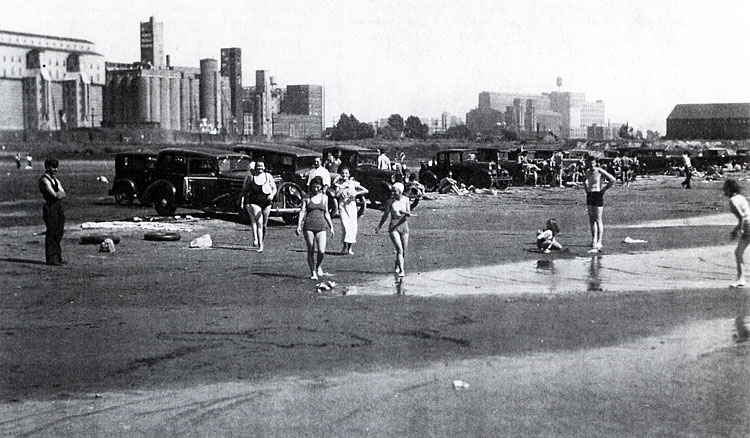
1931 photo of the first bathers at Times Beach. Image source: TBHM
In mid-August, 1931, lifeguards were on duty at the new Times Beach, so named because that's what people had been calling it since the newspaper started the campaign. Access was via the South Michigan bridge over the City Ship Canal (a bridge that no longer exists). The city congratulated The Times for having pushed the idea.
The optimism by the two bacteriologists was unwarranted. Within a few years, the Board of Health announced that the coliform bacteria was 200 times above the dangerous level. Police patrols were posted to prevent people from going into the water. The first dream of Times Beach ended.
1951 map of the harbor area. Although the Seaway Piers have been created from part of the former Times Beach land, the rest of the beach area is the same as it had been for decades.The beach area is shaded in red.
On May, 23, 1952, the city acquired 11 acres of the 62-acre Times Beach site from the U.S., with the provision that it be developed as recreation.
In 1953, the Courier-Express described Times Beach as "a desolate, weed-grown cresent of beach." But several parties were again calling for a public beach there. The article described the factors against such a venture. The coliform bacteria count was called "very bad." The two small breakwalls 200 yards offshore made the water stagnant, encouraging algae growth which created a stench during hot months. Pollution from industries was an overwhelming factor, as Buffalo River water discharged from the Buffalo River through the Union Ship Canal washed back to shore along Times Beach. The City Planning Commission concluded, as the Courier-Express put it, "much of the pollution is 'uncontrollable.' Uncontrollable means it would cost too much for industry to regulate."
Several other reasons were cited as making the dream of Times Beach in 1953 unreasonable. The beach was less tha ten feet from Furhmann Boulevard; railroad tracks had been laid and industries encroached, making the 1.5 mile walk from the Michigan Street bridge unsafe; there was no bus service to the beach; there was little space for parking; and the beach was close to the unprotected bank of the 25' deep City Ship Canal.
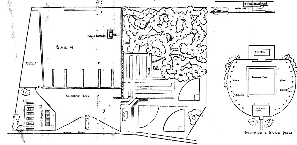
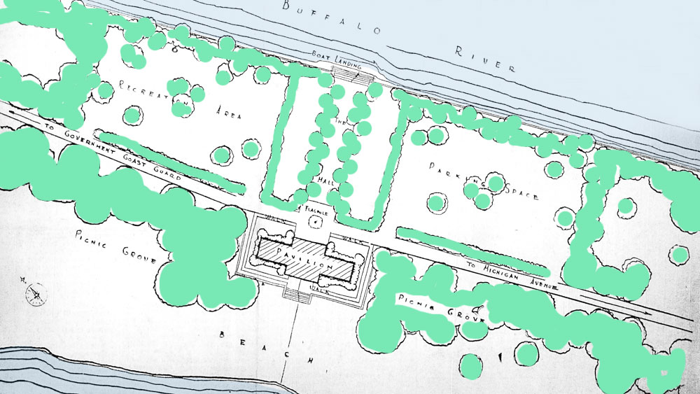
One more attempt was made in the 1960's to remodel the Times Beach area into a waterfront park. Note that there would be swimming pools installed, a nod to the continuing pollution problems. Image source: Courier-Express.
Private developers came forward in 1959 with an offer to purchase this land for a planned "industrial park of waterfront plants and businesses." This prompted an immediate response from the Niagara Frontier Port Authority which had already requested the land be turned over to it for long-range port planning. The city approved the NFPA request three weeks later.
In 1966, the idea of a waterfront park was once again raised. The design above showed a full-feature park with passive and active recreational opportunities. To complete the design's execution, however, would require that the U.S. government sell or otherwise cede ownership of the other 51 acres of Times Beach.
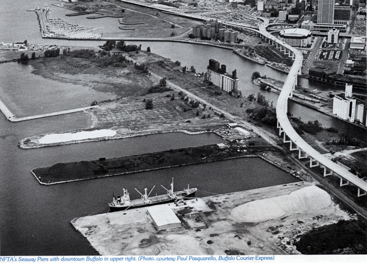
1978 aerial photo of the former Times Beach area. The Seaway Piers were largely used at that time for storage of salt and bulk cargo. The ice boom was stored in the area that appears to have dotted lines running through it. The dike for the Buffalo River dredgings is the squared portion at top left.
"Recreation Plans by City Quashed" were the headlines in September, 1967. The U.S. Army Corps of Engineers announced its plans to use the 51 acres for disposal of dredgings from the Buffalo River. Assistant city corporation counsel Abraham Birnbaum said, "They feel any property of the federal government should be put to its best use and that the best use for this property would be for the storage of dredging material from the Buffalo River."
Where the plans of humans fail, however, Nature succeeds. By 1978, the Times Beach dredging site had become an important site for migrating and breeding birds. At a public hearing, the Buffalo Ornithological Society urged the city to carefully proceed with dividing the Times Beach area to allow a wildlife habitat to continue to evolve. A planner for the Community Development Department called for active recreation instead. And the NYS Department of Environmental Protection said that the Society's plans were in keeping with the intent of the Freshwater Wetlands article of the state Environmental Conservation Law.
The Times Beach Nature Preserve, officially designated as such in 2004, has thrived for a generation, a manmade wetlands, open to the public for observation.
For more information, see the web of the Friends of Times Beach Nature Preserve
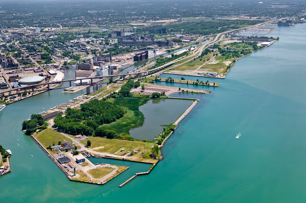
Special thanks to photographer James Cavanaugh for permission to use his 2005 aerial photo of the Times Beach area.